

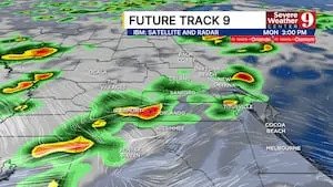
Typical July weather is settling in across Central Florida on Monday, with warm, humid conditions and another round of scattered afternoon thunderstorms.
High temperatures will climb into the upper 80s and lower 90s, while humidity will make it feel even hotter.
Scattered showers and thunderstorms are expected to develop a little earlier than usual, with activity beginning around midday before becoming more widespread as storms move east toward the Space Coast and beaches through the evening.
Some storms could produce gusty winds, frequent lightning, and heavy downpours, so residents should be prepared for rapidly changing weather if spending time outdoors.
Looking ahead, Tuesday will bring a similar pattern, with seasonable heat and scattered afternoon storms.
By the middle of the week, however, a plume of Saharan dust is expected to move into the region.
The drier air associated with the dust should reduce afternoon storm coverage, but it will also allow temperatures to climb.
With fewer storms providing relief, another stretch of hotter weather is expected.
Combined with high humidity, afternoon heat index values will reach between 102 and 107 degrees.
Click here to download our free news, weather and smart TV apps. And click here to stream Channel 9 Eyewitness News live.

See More: https://www.ubirataonline.com.br