

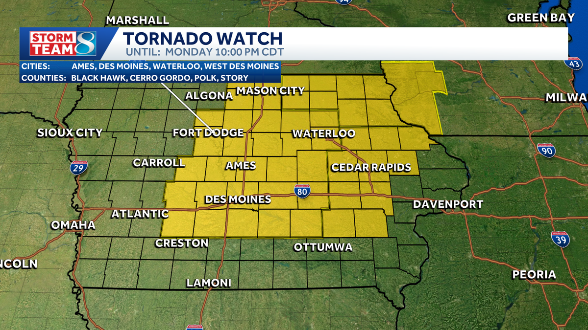
Iowa weather: Tornado watch until 10 p.m.
Right, well, we know our storm teammate has been all over what’s been happening severe weather wise across our state today. Let’s get back out to David. David, hopefully you had *** chance to catch your breath *** little bit because it was 2 hours nonstop for you guys. Yes, yes, it was pretty busy and we still have *** couple of pretty strong storms out there right now. In fact, *** new severe thunderstorm warning for the Ames area down toward Huxley because of this storm. Look at that. Impressive picture right now. This is from the DOT camera at Highway 30, the flyover from northbound I-35. So we are looking to the north northwest. This is *** shelf cloud coming into Ames right now and some interesting color right there. Some high winds likely with this storm as it comes into the Ames area and perhaps. Some half dollar sized hail as well, but I think the main risk with this storm is going to be the high winds as this surges in. So you can see that shelf cloud, some low hanging clouds right there. That’s the strong winds surging out ahead of this storm and it will likely come with some torrential rainfall as well. I want to check *** couple of the other views here. This is I-35 just north of Ames was hoping to see some of the sky, but here on Highway 30 here just west of University Avenue in Ames, the trees are certainly blown. You can see those dark clouds coming on in. And just to the east of I-35 on Highway 30 as well, watching those darker clouds as they roll their way in. So this is the cluster of storms now that we are watching. We had one round of storms that developed north of Algona raced off to the east, east of Marshalltown that continues to dive south here. I had one powerful storm that rolled through Hamilton and Astory counties with some. Baseball sized tail. Now we’re watching *** new storm that is working its way into northern Story County right here, and that is the storm that we were just looking at severe thunderstorm warning here for Story County. This goes until 7 o’clock. High winds, the main risk and perhaps some ping pong ball sized hail as well with this storm as it continues to drop southward at around 30 miles an hour. Also have *** severe thunderstorm warning here for this storm just southwest of Marshalltown. This goes until 7 o’clock as well. Some hail and gusty winds with that storm, but really the strongest storm right now just moved through Story City once again right over Gilbert moving into Ames as we speak, and wind is likely the biggest threat with this. You can see some of these bright greens and yellows right there. That is potentially some pretty strong winds, you know, we’re talking wind speeds maybe up to 70-75 MPH. That is, you know, *** few 100 ft 2000 ft up in the air, so it may not. Be making it all the way to the ground, but certainly some 60 mph winds are not out of the question with this storm as it moves south into Ames. So that’s going to bring it into Ames here in about the next 5 to 10 minutes already affecting the north side of town, and that will continue to raise southward. We’ll have to watch this storm as it is going to be making its way potentially into southeastern Story County and maybe into parts of Polk and Jasper County here over the next hour. All of this area also under. Tornado watch until 10 o’clock here tonight that will likely be canceled before 10 o’clock, but certainly some storms making their way in, and it will bring some relief from the heat. 97 degrees still here in Des Moines, but look at Ames, 77 because of that storm coming through. 97 in Grams, 96 in Norwalk. So there’s the cooler air already taking shape now with those storms, 75 in Iowa Falls. The heat index here in town 106, so still baking when you step outside. So this line continues to drop southward. It should be moving into the metro. Uh, over the next hour, hour and *** half, and then it’ll drop our temperatures down to the 60s and 70s here tonight. Tomorrow, look at this 84, *** little breezy. That north wind will be strong, 79 on Wednesday. Nice little break from the heat, but the higher temperatures do build back in by the time we get to the weekend.
Our current stretch of heat will peak Monday and bring strong thunderstorms back to parts of Iowa. A Tornado Watch is in effect until 10 p.m. for much of central Iowa, including the Des Moines metro and most of eastern Iowa.Here’s what to expect:Widespread heat indices of 100-105 degrees Monday afternoonMore storms cross Iowa late Monday afternoon/eveningSevere weather is possible during the evening hours Baseball-sized hail reported Heat and humidity intensify Monday afternoon A Heat Advisory will be in effect for most areas until 8 p.m. Monday.Temperatures will surge into the mid-90s, while humidity increases to tropical levels. Expect the heat index to be around 105 degrees at times through early evening.Storms fire this afternoon and eveningStrong to severe storms are likely by Monday afternoon and evening.These will fire ahead of a front coming into northern/northwest Iowa during the early afternoon. Storms could ignite as soon as 2-4 p.m., then become more widespread into the evening hours. Severe weather is more likely with this round than the storms in eastern Iowa earlier today.Damaging wind gusts are the main threat from these storms as they move southeast Monday evening. Large hail is possible, too. A tornado isn’t out of the question especially across eastern portions of Iowa.More smoke possibleThunderstorms should knock down the worst of eastern Iowa’s wildfire smoke lingering from Sunday.The bad news is that a veil of smoke might follow Monday night’s cold front into Iowa.Smoky haze currently up in North Dakota, Montana, and Canada looks to flow southward toward Iowa overnight Monday into early Tuesday.It’s possible this band of smoke passes all the way through Iowa before the sun rises Tuesday, but some haze could linger into the morning, especially southern parts of the state. This smoke should not be as thick as what affected the state on Sunday.
Our current stretch of heat will peak Monday and bring strong thunderstorms back to parts of Iowa. A Tornado Watch is in effect until 10 p.m. for much of central Iowa, including the Des Moines metro and most of eastern Iowa.
Here’s what to expect:
- Widespread heat indices of 100-105 degrees Monday afternoon
- More storms cross Iowa late Monday afternoon/evening
- Severe weather is possible during the evening hours
Baseball-sized hail reported



Heat and humidity intensify Monday afternoon
A Heat Advisory will be in effect for most areas until 8 p.m. Monday.
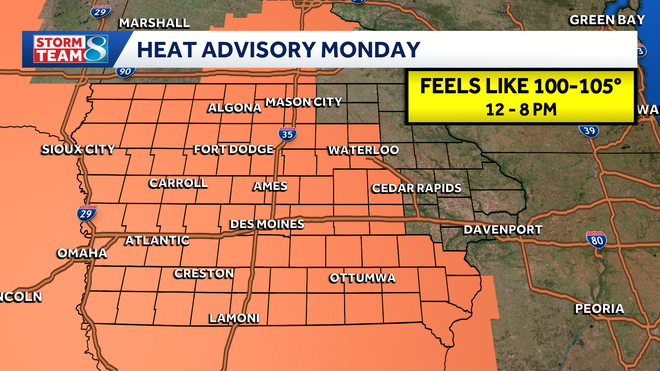
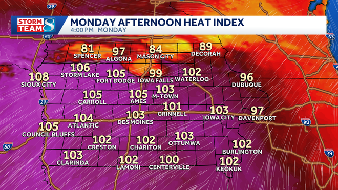
Temperatures will surge into the mid-90s, while humidity increases to tropical levels. Expect the heat index to be around 105 degrees at times through early evening.
Storms fire this afternoon and evening
Strong to severe storms are likely by Monday afternoon and evening.
These will fire ahead of a front coming into northern/northwest Iowa during the early afternoon.
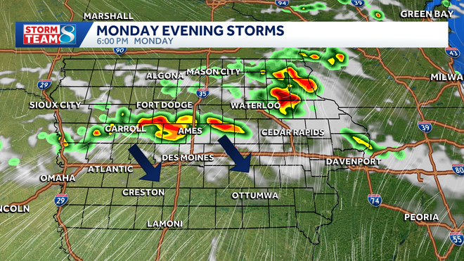
Storms could ignite as soon as 2-4 p.m., then become more widespread into the evening hours.
Severe weather is more likely with this round than the storms in eastern Iowa earlier today.
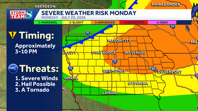
Damaging wind gusts are the main threat from these storms as they move southeast Monday evening. Large hail is possible, too. A tornado isn’t out of the question especially across eastern portions of Iowa.
More smoke possible
Thunderstorms should knock down the worst of eastern Iowa’s wildfire smoke lingering from Sunday.
The bad news is that a veil of smoke might follow Monday night’s cold front into Iowa.
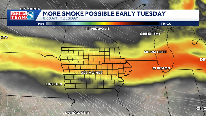
Smoky haze currently up in North Dakota, Montana, and Canada looks to flow southward toward Iowa overnight Monday into early Tuesday.
It’s possible this band of smoke passes all the way through Iowa before the sun rises Tuesday, but some haze could linger into the morning, especially southern parts of the state. This smoke should not be as thick as what affected the state on Sunday.
See More: https://www.ubirataonline.com.br