

AT RISK OF SEVERE WEATHER AGAIN THIS EVENING. THAT’S WHY WE ARE CALLING THIS A WEATHER IMPACT DAY, BECAUSE THE WEATHER COULD TURN AT ANY MOMENT. WE’VE STILL GOT PLENTY OF STORMS ONGOING RIGHT NOW. STRONGEST ONES GOOD NEWS ARE WAY UP IN NORTHEAST IOWA AT THIS HOUR, SO THAT’S A POSITIVE, AT LEAST FOR US LOCALLY. BUT WE DO STILL HAVE SOME STORMS HAPPENING LIVE. LOOK FROM UP IN MARSHALLTOWN A SHORT WHILE AGO. THERE’S A LITTLE BIT OF RAIN UP THIS DIRECTION. NOW WE’RE JUST LOOKING AT A THUNDERSTORM ABOUT 15 MILES FARTHER UP TO THE NORTH, UP OUT OF MARSHALL COUNTY. THIS IS ANOTHER STORM, ANOTHER LITTLE CLUSTER OF STORMS, I GUESS I SHOULD SAY, IN PARTS OF EASTERN HARDIN COUNTIES AND THEN IN GRUNDY COUNTY AGAIN. HERE TOO, THERE IS A SEVERE THUNDERSTORM WARNING ON THIS STORM UNTIL 545 WARNED FOR THE POTENTIAL OF INCH DIAMETER HAIL, MAYBE SOME 60 MILE PER HOUR WIND GUSTS. THE MAIN STRONGEST AREA WHERE THERE MIGHT BE SOME HAIL IS KIND OF JUST TO THE WEST OF GRUNDY CENTER. THERE, ALONG HIGHWAY 175. WOULDN’T SURPRISE ME IF THIS WAS. WASN’T THE ORIGINAL STORM WARNING, BUT WEST OF ELDORA ON HIGHWAY 175, AS YOU HEAD OUT THAT DIRECTION ALSO COULD PRODUCE A LITTLE BIT OF SOME HAIL. THAT AREA ALREADY HAD SOME STRONG THUNDERSTORMS EARLIER ON THIS AFTERNOON. WE DO HAVE ANOTHER LOCALLY, AT LEAST ONE MORE STORM THAT’S WARNED FOR SEVERE WEATHER TOO. THIS SEVERE THUNDERSTORM WARNING DOWN IN THE OTTUMWA AREA STILL WARNED OF STORMS MOVING NORTHEAST. BY THE WAY ABOUT 40 ISH MILES PER HOUR. I GUESS WE CAN TRY TO PUT THESE STORMS IN MOTION HERE FOR YOU, JUST SO YOU CAN SEE THAT MOVEMENT AS THEY HEAD UP THAT DIRECTION. THIS IS GOING TO EVENTUALLY HEAD UP INTO PARTS OF KEOKUK COUNTY. BEFORE TOO LONG, I JUST SAW A PICTURE NOT TOO LONG AGO FROM DOWN IN THE OTTUMWA AREA. LOOK BIGGER THAN AN INCH IN DIAMETER. HAIL SITTING IN THE PALM OF SOMEONE’S HAND. BUT THAT’S WHAT YOU’RE DEALING WITH THIS WAY. LUCKILY, NO TORNADO THREAT. A FEW OTHER NON-SEVERE CELLS BACK FARTHER SOUTH AND WEST OF THAT RIGHT OVER RATHBUN LAKE AT THIS HOUR. AND THEN FROM CENTERVILLE BACK WESTWARD THROUGH APPANOOSE COUNTY, JUST TO THE EAST OF SEYMOUR. SO THAT’S OUR SITUATION HERE IN SOUTHEASTERN IOWA. IF WE WIDEN THINGS OUT TO THE WHOLE STATE, YOU NOTICE NOT MUCH ELSE GOING ON. BASICALLY, IF YOU’RE WEST OF I-35, YOU’RE PROBABLY DONE FOR THE EVENING HOURS, AT LEAST IN TERMS OF SEVERE WEATHER. I WOULD SAY THERE IS STILL TECHNICALLY THE TORNADO WATCH UNTIL 10:00, COLORED IN YELLOW, ALTHOUGH THE HIGHEST POTENTIAL PROBABLY OVER THIS DIRECTION FROM WATERLOO AND CEDAR FALLS, CEDAR RAPIDS UP TOWARDS DUBUQUE AND THEN EVENTUALLY INTO PARTS OF WISCONSIN. THAT’S WHERE STORMS WILL BE STRONGEST, MOST WIDESPREAD HERE. AS WE HEAD THROUGH THE NEXT FEW HOURS. AND THEN AS WE GO INTO TONIGHT, WE’LL WATCH AFTER DARK, BECAUSE WE’RE GOING TO HAVE A LITTLE BIT BACK, ANOTHER BATCH OF MOISTURE THAT FLOWS IN ABOUT A MILE UP ALOFT ABOVE THE GROUND FROM THE SOUTH TO THE WEST. I MIGHT BE ABLE TO POP UP SOME MORE STORMS FOR US, NOT NECESSARILY AS LIKELY TO BE SEVERE, BUT LATER THIS EVENING AFTER TEN MIDNIGHT, KIND OF IN THAT TIME FRAME INTO THE FIRST PART OF TONIGHT. SO WE’LL KEEP AN EYE ON THAT INTO TOMORROW. THEN QUIETER CONDITIONS AS WE START OUR WEDNESDAY. HERE’S WHAT WE’RE LOOKING AT WITH EARLIER TODAY. WE’RE WATCHING STORMS FIRE ALONG THIS KIND OF STATIONARY FRONT TOMORROW AFTERNOON, ANOTHER LOW PRESSURE CENTER DEVELOPS. AND THAT’S GOING TO COME INTO SORT OF WEST CENTRAL IOWA. GIVE US A LITTLE BIT OF A NUDGE. WE NEED TO FORM SOME MORE STORMS AND THEN THOSE COULD BE STRONG. WE’LL GET TO A LULL IN THE ACTION ON THURSDAY. AND THEN A BIGGER SYSTEM WILL PUSH A COLD FRONT AND MORE WIDESPREAD THUNDERSTORMS INTO THE DAY ON FRIDAY. SO SEVERE WEATHER ACTUALLY OVER THE NEXT FEW DAYS LOOKS MOST LIKELY AS WE HEAD INTO FRIDAY. AT LEAST. COVERAGE OF STORMS. MOST WIDESPREAD STORMS FRIDAY AFTERNOON. FRIDAY EVENING. TOMORROW DURING THE AFTERNOON. MAYBE AS SOON AS 3 OR 4:00 AND THEN INTO THE EVENING. THERE’S A LEVEL TWO RISK, NOT AS HIGH OF SEVERE STORMS IN PARTS OF THE STATE. LET’S SHOW YOU THAT BRIEFLY HERE TOMORROW. THIS IS STILL A LITTLE BIT FLUID DEPENDING ON WHAT UNFOLDS TONIGHT. OKAY. IT’S ONE OF THOSE SORT OF FORECASTS, BUT TOMORROW AFTERNOON, WATCH A LITTLE BIT OF THAT CLEARING WORK INTO IOWA, THAT LOW PRESSURE TO THE WEST. WE START TO POP UP SOME STORMS SOMEWHERE IN THE VICINITY OF THE I-35 CORRIDOR, SOUTH CENTRAL EASTERN IOWA. AND THOSE QUICKLY MOVE OUT OF OUR PART OF THE STATE. AND WE DON’T HAVE AS MUCH OF A SEVERE WEATHER THREAT BY THE EVENING HOURS. SO WE’LL WATCH TOMORROW AND FRIDAY. IN PARTICULAR. KEEP WITH US FOR THAT TOMORROW ON THURSDAY, JUST SOME SUNSHINE, QUIETER DAY BY COMPARISON. UP AROUND 80 DEGREES. COOL WINDS BLOWING AFTER FRIDAY STORMS. LOOK AT SATURDAY HIGH ONLY AROUND 50. GUSTY WINDS, SOME LIN
LIVE WEATHER UPDATES: Severe weather rolls through central, eastern Iowa

Active weather is ahead for Iowa this week, including a few different opportunities for severe storms.Here’s what to expect:Another round of strong to severe storms in central and eastern Iowa Tuesday afternoonChances return Wednesday, especially for southern and eastern IowaFriday brings the final chance for strong to severe storms to the stateInteractive Radar | Weather AlertsTracking severe weather in central IowaKCCI’s Abigail Kurten in Storm Chaser tracking storms in Grundy CountySevere thunderstorm warningThe NWS has issued a severe thunderstorm warning for parts of Hardin, Franklin, Grundy and Butler counties until 5:45 p.m. Tuesday. Trained weather spotters have located a storm capable of 60 mph winds and quarter sized hail.Tornado watch in effect until 10 p.m.The National Weather Service has issued a tornado watch for much of central and eastern Iowa until 10 p.m. Tuesday.The watch includes Allamakee, Benton, Black Hawk, Boone, Bremer, Buchanan, Butler, Cedar, Chickasaw, Clayton, Clinton, Dallas, Delaware, Dubuque, Fayette, Floyd, Franklin, Grundy, Hamilton, Hardin, Howard, Iowa, Jackson, Jasper, Johnson, Jones, Keokuk, Linn, Madison, Mahaska, Marion, Marshall, Muscatine, Polk, Poweshiek, Scott, Story, Tama, Warren, Washington and Winneshiek counties.Viewers submit photos of hail and storm cloudsStorms likely Tuesday in central and eastern IowaA stalled out front cutting across the state this afternoon will likely be the focus for storm development by midafternoon into the evening hours. Strong to severe storms will be possible near and south of the front.South of the boundary, highs will surge into the mid-80s with high humidity levels as well. This will provide plenty of fuel for any storms that form today.Storms could form as early as 2 to 4pm near and just east of I-35. These storms will quickly intensify, and will bring the potential for very large, damaging hail, high winds, and some tornado risk.The main question for this afternoon remains just how many storms actually fire up. It is possible that only a couple of storms actually develop, which would keep the severe risk rather isolated. However, any storms that develop could be very intense, so pay close attention to development this afternoon.As storms push into eastern Iowa, they will likely grow in intensity. This is where the very large hail risk, potentially to around 3 inches in size, and the tornado risk will be highest. An intense tornado is possible if storms are able to take advantage of all the ingredients available today.A second area to watch is southern Iowa later tonight. Increasing southerly flow may help to develop an additional wave of storms spreading from south to north. With these storms occurring overnight, the severe risk is low. However, heavy rainfall and some small hail will be possible.Another chance for storms comes WednesdayStrong storms are possible again Wednesday, with a low chance for a few storms in the morning, and another round of strong to severe storms possible by the afternoon and evening.A stalled out front will still be sitting across parts of the state, and will be the focus for storm development once again going into the afternoon and evening hours. However, where that front sets up is still a little in question, as the Tuesday storms will have an influence on how far north or south it is able to move.More severe weather, including damaging winds, hail and tornadoes, are possible, but it will depend exactly what unfolds the day before on Tuesday.There still is the possibility Wednesday’s system moves fast enough that central Iowa avoids any storms at all.» Subscribe to KCCI’s YouTube page» Download the free KCCI app to get updates on the go: Apple | Google Play
Active weather is ahead for Iowa this week, including a few different opportunities for severe storms.
Here’s what to expect:
- Another round of strong to severe storms in central and eastern Iowa Tuesday afternoon
- Chances return Wednesday, especially for southern and eastern Iowa
- Friday brings the final chance for strong to severe storms to the state
Interactive Radar | Weather Alerts
Tracking severe weather in central Iowa
KCCI’s Abigail Kurten in Storm Chaser tracking storms in Grundy County
Severe thunderstorm warning
The NWS has issued a severe thunderstorm warning for parts of Hardin, Franklin, Grundy and Butler counties until 5:45 p.m. Tuesday. Trained weather spotters have located a storm capable of 60 mph winds and quarter sized hail.
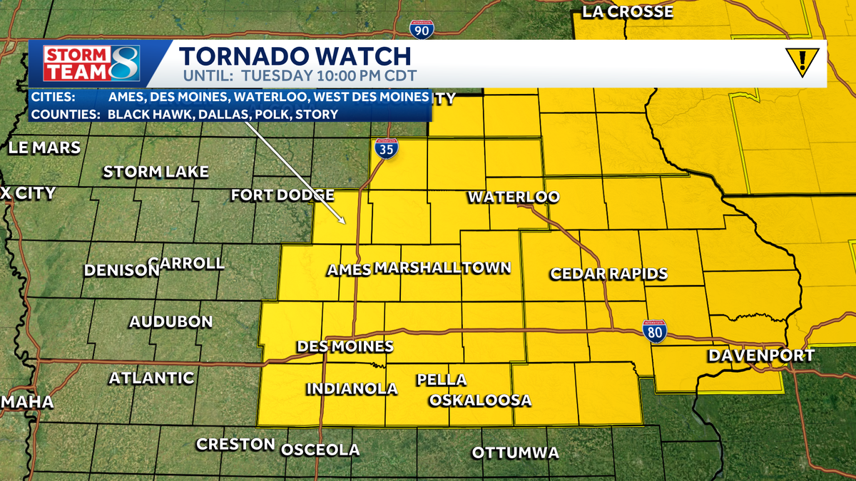
Tornado watch in effect until 10 p.m.
The National Weather Service has issued a tornado watch for much of central and eastern Iowa until 10 p.m. Tuesday.
The watch includes Allamakee, Benton, Black Hawk, Boone, Bremer, Buchanan, Butler, Cedar, Chickasaw, Clayton, Clinton, Dallas, Delaware, Dubuque, Fayette, Floyd, Franklin, Grundy, Hamilton, Hardin, Howard, Iowa, Jackson, Jasper, Johnson, Jones, Keokuk, Linn, Madison, Mahaska, Marion, Marshall, Muscatine, Polk, Poweshiek, Scott, Story, Tama, Warren, Washington and Winneshiek counties.

Viewers submit photos of hail and storm clouds


Storms likely Tuesday in central and eastern Iowa
A stalled out front cutting across the state this afternoon will likely be the focus for storm development by midafternoon into the evening hours. Strong to severe storms will be possible near and south of the front.

South of the boundary, highs will surge into the mid-80s with high humidity levels as well. This will provide plenty of fuel for any storms that form today.
Storms could form as early as 2 to 4pm near and just east of I-35. These storms will quickly intensify, and will bring the potential for very large, damaging hail, high winds, and some tornado risk.
The main question for this afternoon remains just how many storms actually fire up. It is possible that only a couple of storms actually develop, which would keep the severe risk rather isolated. However, any storms that develop could be very intense, so pay close attention to development this afternoon.

As storms push into eastern Iowa, they will likely grow in intensity. This is where the very large hail risk, potentially to around 3 inches in size, and the tornado risk will be highest. An intense tornado is possible if storms are able to take advantage of all the ingredients available today.

A second area to watch is southern Iowa later tonight. Increasing southerly flow may help to develop an additional wave of storms spreading from south to north. With these storms occurring overnight, the severe risk is low. However, heavy rainfall and some small hail will be possible.

Another chance for storms comes Wednesday
Strong storms are possible again Wednesday, with a low chance for a few storms in the morning, and another round of strong to severe storms possible by the afternoon and evening.

A stalled out front will still be sitting across parts of the state, and will be the focus for storm development once again going into the afternoon and evening hours. However, where that front sets up is still a little in question, as the Tuesday storms will have an influence on how far north or south it is able to move.
More severe weather, including damaging winds, hail and tornadoes, are possible, but it will depend exactly what unfolds the day before on Tuesday.
There still is the possibility Wednesday’s system moves fast enough that central Iowa avoids any storms at all.
» Subscribe to KCCI’s YouTube page
» Download the free KCCI app to get updates on the go: Apple | Google Play