

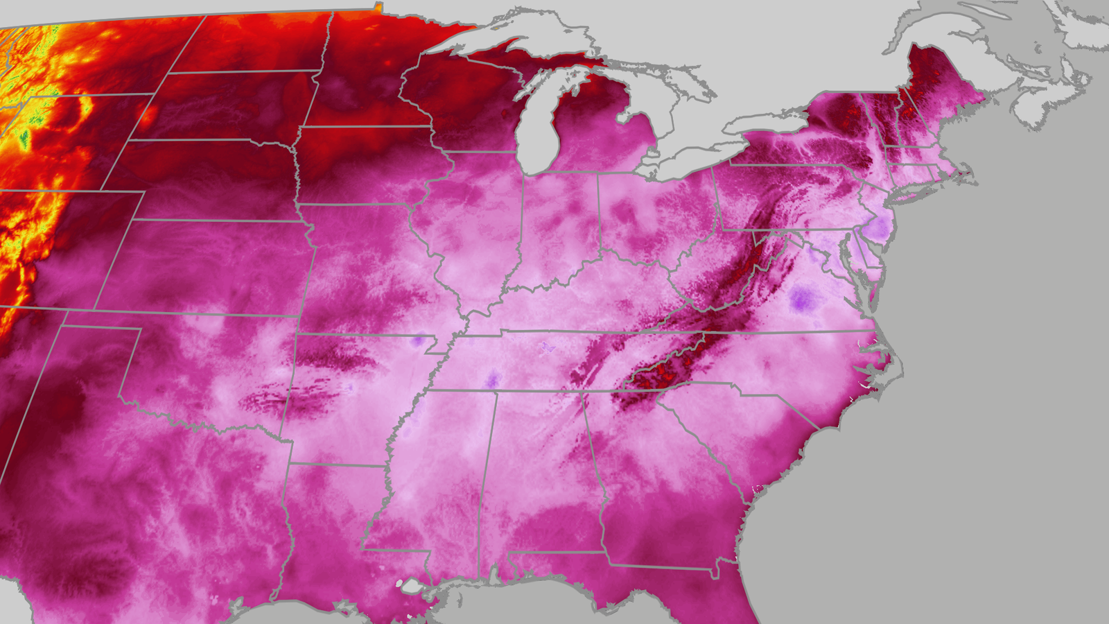
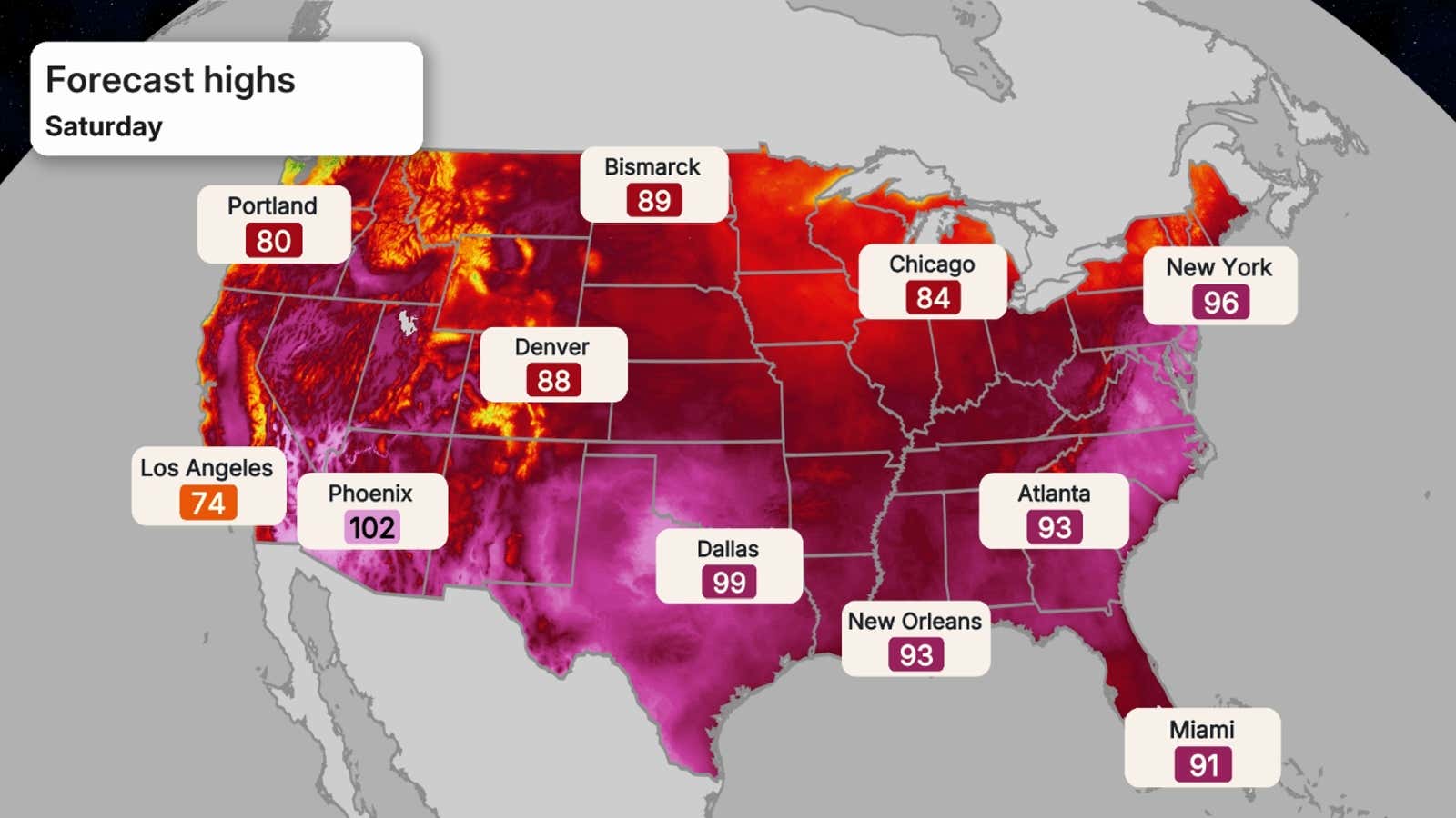
A widespread, major heat wave spread from the Midwest to the East and will remain in place through the Fourth of July weekend with both oppressive humidity and blistering highs that are flirting with some all-time records in parts of the mid-Atlantic states.
Through July Fourth, over 165 million Americans in the Midwest and East have been at risk of either “major” or “extreme” heat-related health issues, according to the National Weather Service experimental HeatRisk product.
Triple-digit heat indices are expected for many, and daily low temperatures won’t drop below the mid-80s for some, offering little relief at night.
(MAPS: 10-Day US forecast highs, lows)
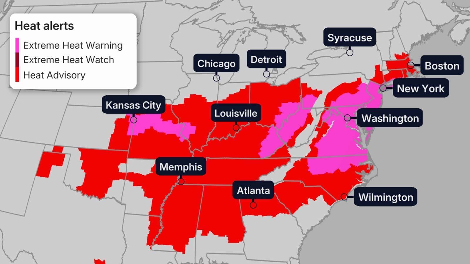
Heat Alerts
The NWS has issued numerous extreme heat warnings and advisories for the eastern half of the country this week, plotted in the map below.
Alerts still stretch from the Central Plains through the Midwest, South and Northeast.
An extreme heat warning means that dangerous heat is either happening now or imminent. Heat advisories are issued for heat that is less unusual, but could still be dangerous.
(CURRENT US MAPS: Temperature | Heat Index | Dew Point)
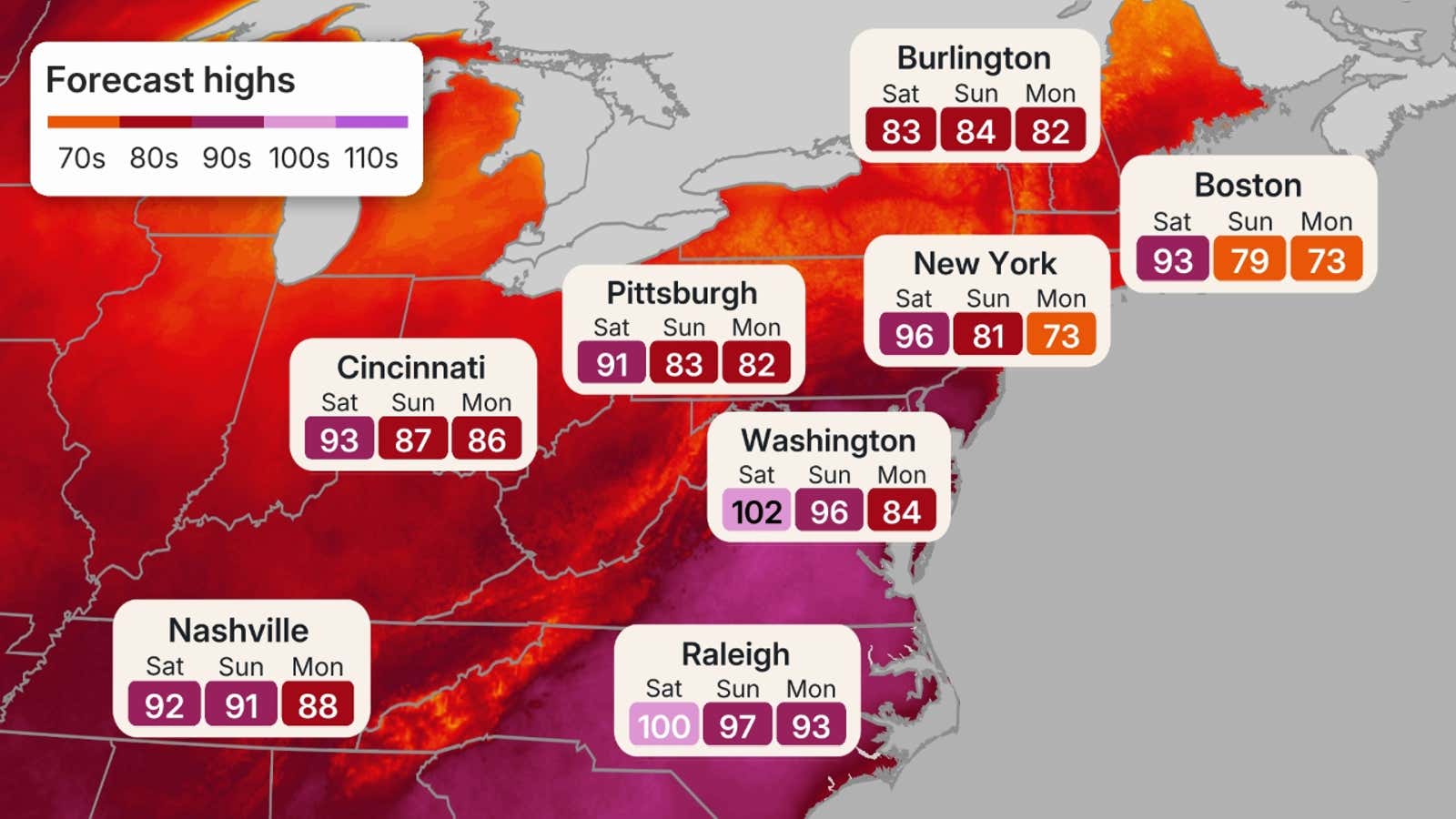
Northeast highlights
In much of the Northeast, this heat wave is lasting through at least part of the holiday weekend.
Parts of the I-95 corridor from southern New England to Virginia could reach triple-digit highs each afternoon through Saturday.
New York City has already seen its first century club visit since 2012.
Life-threatening heat indices will climb above 100 degrees in many areas and will likely top 110 degrees in the hottest parts of the mid-Atlantic states.
And overnight lows may struggle or even fail to drop below 80 degrees in the heart of Philly, Baltimore, New York, Boston and Washington, D.C., offering little nighttime relief, another life-threatening factor in heat waves.
(MAPS: 10-Day US Forecast Highs/Lows)
Records could be shattered
In Philadelphia and Washington, D.C., highs could approach all-time records — both 106 degrees. This heat wave could also flirt with record-long streaks of 100-degree-plus highs in each city (3 straight in Philly, 4 straight in Washington, D.C.).
New York City’s Central Park reached 100 degrees Thursday, their first triple-digit high in almost 14 years (July 18, 2012).
New York City, Philly and Washington, D.C., could also flirt with their all-time record hot low temperatures (84 in NYC and D.C., 83 in Philly) most recently set during the late July 2011 heat wave.
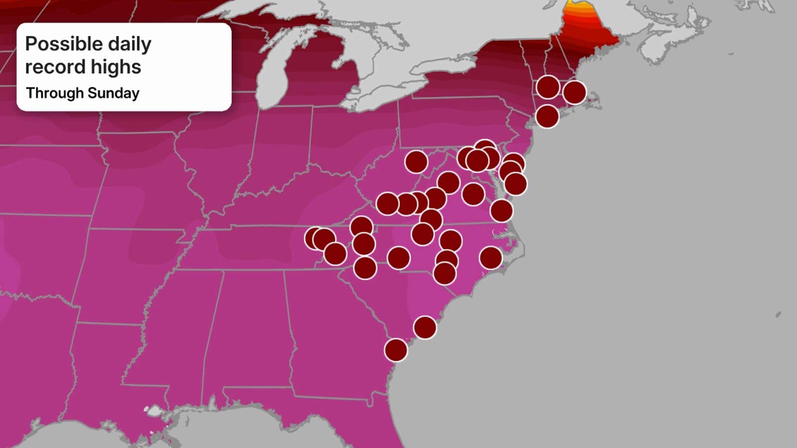
Hundreds of daily record highs and warm lows will fall by the wayside, as well, through this weekend in the Northeast.
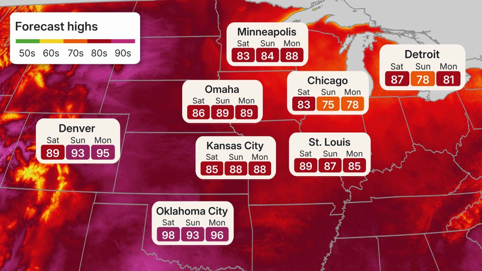
Central US highlights
The heat intensified in the Plains and Midwest this past weekend and locked in place in the Great Lakes through Friday.
Parts of the upper Midwest are cooling off into this weekend, though that’s relative, considering it’s only in the 80s instead of the 90s.
When you factor in the heat index, many across the Central Plains and mid-Mississippi Valley will feel like the triple digits, making conditions outright dangerous to be exposed to for long periods. This includes places like Omaha, St. Louis and Kansas City.
South
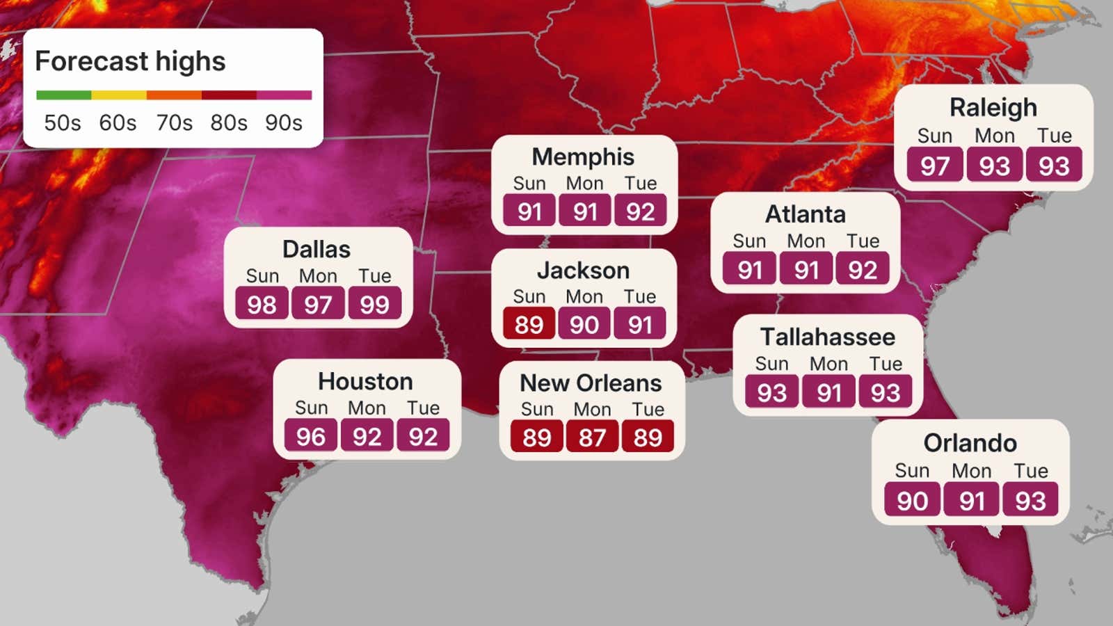
While the South is used to hot summers, the heat that has moved in is both persistent and oppressive.
Much of the region had highs in the 90s last weekend, and that torrid heat has continued to linger through all of this week. Some locations could even top 100 degrees in both the Southern Plains and in the Southeast from Virginia into the Carolinas, where daily record highs are most likely.
Add in the southern humidity, and heat indices will be well over 100 from Texas to the Carolinas.
How long will the heat last?
The heat has eased a bit over most of the Midwest, and highs in the 90s may be limited to near the Ohio Valley.
There is also some relief for parts of New England and the interior Northeast by Sunday.
A little more heat relief may arrive for the mid-Atlantic states by next Monday or Tuesday, as the heat dome responsible for this heat wave may shift westward, bringing the majority of the above-average heat back to parts of the Plains and West.
(MORE: 5 things to know to stay safe in a heat wave)
Some records have fallen
One all-time heat record has already been tied.
On Tuesday, La Crosse, Wisconsin’s low temperature was only 81 degrees, tying it with four other dates for the city’s all-time warmest low dating to 1872. That most recently happened on July 4, 2012.
Various other record warm lows for the date were set Tuesday in Rockford, Illinois (77); Louisville, Kentucky (79); and Topeka, Kansas (79).
Dallas saw their low drop to only 81 degrees Monday, tying the previous daily record set just two years ago.
For Tuesday, numerous warm low records were broken. Louisville, Kentucky, only fell to 79 degrees. Daily record warm lows also fell in South Bend, Indiana, Holland, Michigan, Jackson, Kentucky, Dubuque, Iowa and Battle Creek, Michigan.
Daily high temperatures were tied or broken on Wednesday in Roanoke, Virginia (102); Cleveland, Ohio (97); Washington-Dulles (97); Syracuse, New York (96); Montpelier, Vermont (92); and Caribou, Maine (90).
Daily low temperature records fell in Chicago-O’hare (80); Madison, Wisconsin (79); Flint, Michigan (78); Buffalo, New York (75); and Fort Wayne, Indiana (74), among some others.
Thursday saw more than 20 record highs. A few of the most notable are: Newark (104), Philadelphia (103), Washington, D.C. (102), Boston (101), Atlantic City (103), Wilmington (101), New York City’s Central Park (100).
Make sure you check back, as we will continue to update the forecast and keep a close eye on the holiday weekend. For a more detailed forecast for the Fourth of July, see our latest forecast article here.
See More: https://www.ubirataonline.com.br