

A severe thunderstorm watch is in effect until 4 a.m. Monday for much of the Kansas City area as storms continue to develop across eastern Kansas and western Missouri.The watch includes Johnson, Wyandotte, Leavenworth, Miami and Linn counties in Kansas, along with Jackson, Clay, Platte, Cass, Ray, Lafayette, Johnson, Bates, Henry, Carroll, Cooper, Howard, Pettis and Saline counties in Missouri.Kansas City weather updates: 1:38 a.m. – Tornado warning issued for Clay and Jackson counties until 2:15 a.m. This includes a portion of the Kansas City metro, including Independence and Raytown. Take shelter.1:12 a.m. – The strongest storm in the metro is now moving through the Northland. The severe thunderstorm warning remains in effect until 1:45 a.m. for parts of Clay, Platte, Jackson and Wyandotte counties.1:11 a.m. – Some good news for parts of the Northland: the severe thunderstorm warning for portions of Clinton, Clay and Ray counties has been allowed to expire.12:53 a.m. – If the thunder just woke you up, there’s a reason. A severe thunderstorm warning is now in effect until 1:45 a.m. for parts of the Kansas City metro, including portions of Wyandotte, Platte, Clay and Jackson counties.12:45 a.m. – The severe thunderstorm has been allowed to expire in Leavenworth and Wyandotte counties, but remains in effect for Clay and Platte counties. 12:34 a.m. – The severe thunderstorm warning has been canceled for Jackson County. It remains in effect for parts of Leavenworth, Platte, Clay and Wyandotte counties. 12:08 a.m. – A severe thunderstorm warning has been issued for Jackson, Clay, Leavenworth, Platte and Wyandotte counties until 1 a.m. 12:00 a.m. – A tornado warning was issued for Anderson County, Kansas. The forecast: Some neighborhoods may see heavy rain, gusty winds or hail while others remain completely dry.Warm temperatures, sunshine and increasing instability will help fuel storm development through the evening hours. Storms are expected to develop southwest of Kansas City and move east-northeast. A cluster or line of thunderstorms could organize later tonight and continue into the overnight hours.The primary concern with any stronger storms will be damaging wind gusts. Large hail is also possible. While the tornado threat is not zero, it remains very low at this time.
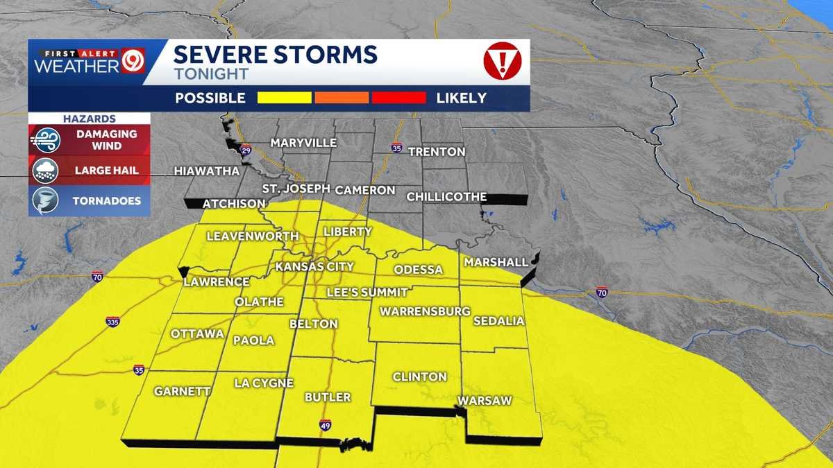
A severe thunderstorm watch is in effect until 4 a.m. Monday for much of the Kansas City area as storms continue to develop across eastern Kansas and western Missouri.
The watch includes Johnson, Wyandotte, Leavenworth, Miami and Linn counties in Kansas, along with Jackson, Clay, Platte, Cass, Ray, Lafayette, Johnson, Bates, Henry, Carroll, Cooper, Howard, Pettis and Saline counties in Missouri.
Kansas City weather updates:
1:38 a.m. – Tornado warning issued for Clay and Jackson counties until 2:15 a.m. This includes a portion of the Kansas City metro, including Independence and Raytown. Take shelter.
1:12 a.m. – The strongest storm in the metro is now moving through the Northland. The severe thunderstorm warning remains in effect until 1:45 a.m. for parts of Clay, Platte, Jackson and Wyandotte counties.
1:11 a.m. – Some good news for parts of the Northland: the severe thunderstorm warning for portions of Clinton, Clay and Ray counties has been allowed to expire.
12:53 a.m. – If the thunder just woke you up, there’s a reason. A severe thunderstorm warning is now in effect until 1:45 a.m. for parts of the Kansas City metro, including portions of Wyandotte, Platte, Clay and Jackson counties.
12:45 a.m. – The severe thunderstorm has been allowed to expire in Leavenworth and Wyandotte counties, but remains in effect for Clay and Platte counties.
12:34 a.m. – The severe thunderstorm warning has been canceled for Jackson County. It remains in effect for parts of Leavenworth, Platte, Clay and Wyandotte counties.
12:08 a.m. – A severe thunderstorm warning has been issued for Jackson, Clay, Leavenworth, Platte and Wyandotte counties until 1 a.m.
12:00 a.m. – A tornado warning was issued for Anderson County, Kansas.
The forecast:
Some neighborhoods may see heavy rain, gusty winds or hail while others remain completely dry.
Warm temperatures, sunshine and increasing instability will help fuel storm development through the evening hours. Storms are expected to develop southwest of Kansas City and move east-northeast.
A cluster or line of thunderstorms could organize later tonight and continue into the overnight hours.
The primary concern with any stronger storms will be damaging wind gusts. Large hail is also possible.
While the tornado threat is not zero, it remains very low at this time.