
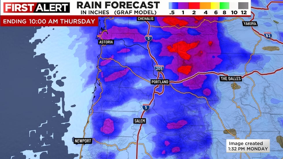
An upper-level low is moving across the region this Monday afternoon, giving us a (somewhat) rare rainy June day. Rain dies down overnight, with just a few scattered light showers Tuesday. The rain is good news, but we expect less than 1″ for most of us west of the Cascades and less than 1/2″ for many of us. If it’s going to be cool/showery, it would be nice to see a big soaking, but clearly that’s not happening in the lowlands.
HEAT WAVE AHEAD
6-7 days from now, afternoon temperatures will be about 40 degrees warmer! At least we will see a gradual rise in temps leading up to our first heatwave of 2026 versus a sudden jump. By the way, in the Portland area we generally consider a heatwave to be 3 days at/above 90 or at least one at/above 95. That 95 number is important because that’s when I believe most people in our climate mentally switch from “yeah, it’s hot but no biggie” to “oh, dang, that’s really hot and I’m going to change my plans”.
QUICK SUMMARY
- Showers end and a long period of dry weather begins Wednesday
- Temperatures gradually rise Thursday-Saturday under sunny skies
- A 3-4 day heatwave is likely Saturday-Tuesday. Temperatures will probably peak in the 96-99 degree range Sunday and/or Monday
- We’re calling Sunday and Monday FIRST ALERT WEATHER DAYS for the very hot afternoon temps
- Daily record high temperatures will likely be set both of those days
WHAT’S AHEAD
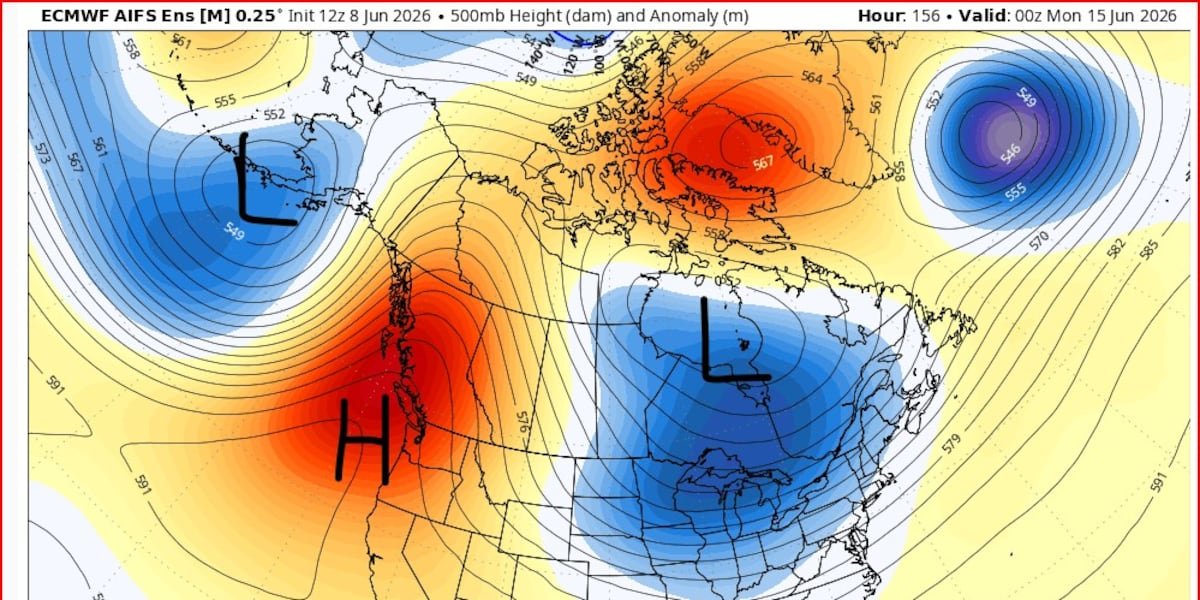
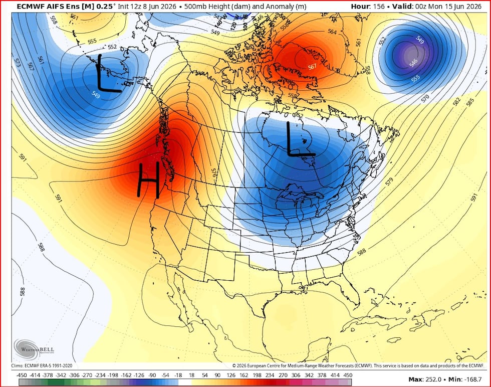
A big ridge of high pressure builds just offshore of the West Coast over the weekend through about next Tuesday. This won’t be a long-lasting or historic heatwave, but it’s gonna get hot! Check out the 500mb chart from the Euro AI ensemble average for next Sunday, the 14th. The red color is the high height anomaly. Notice it’s centered slightly to our west, one indication that it’s not a historic event.
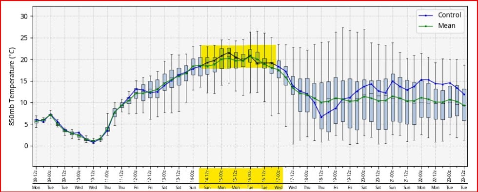
That’s one ingredient for a heatwave. The 2nd is a very warm atmosphere overhead. This is the 850mb Euro ensemble temperature (in C). You see the maximum right around +20 or slightly over Sunday and Monday. Possibly into Tuesday morning.
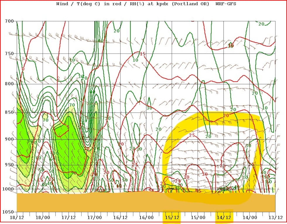
Then notice the “perfect” easterly flow near sea level up to 5,000′ on this cross-section from the WRF-GFS model. The circled yellow area is late Saturday through late Monday. This is when the east wind is blowing down off the Cascades, warming as the air compresses heading downhill.
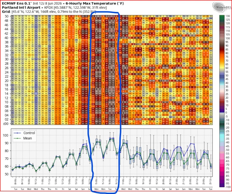
This combo plus sunny skies means temperatures begin to soar Saturday (probably right around 90 in the western valleys), then really peak Sunday and Monday. I love this following chart: 6-hr maximum temperature in Portland from all 51 Euro model ensemble members. The color shading clearly shows the peak temperatures those two days, I’ve circled it too. For that reason we’re calling both Sunday and Monday FIRST ALERT WEATHER DAYS since it’ll be extra hot.
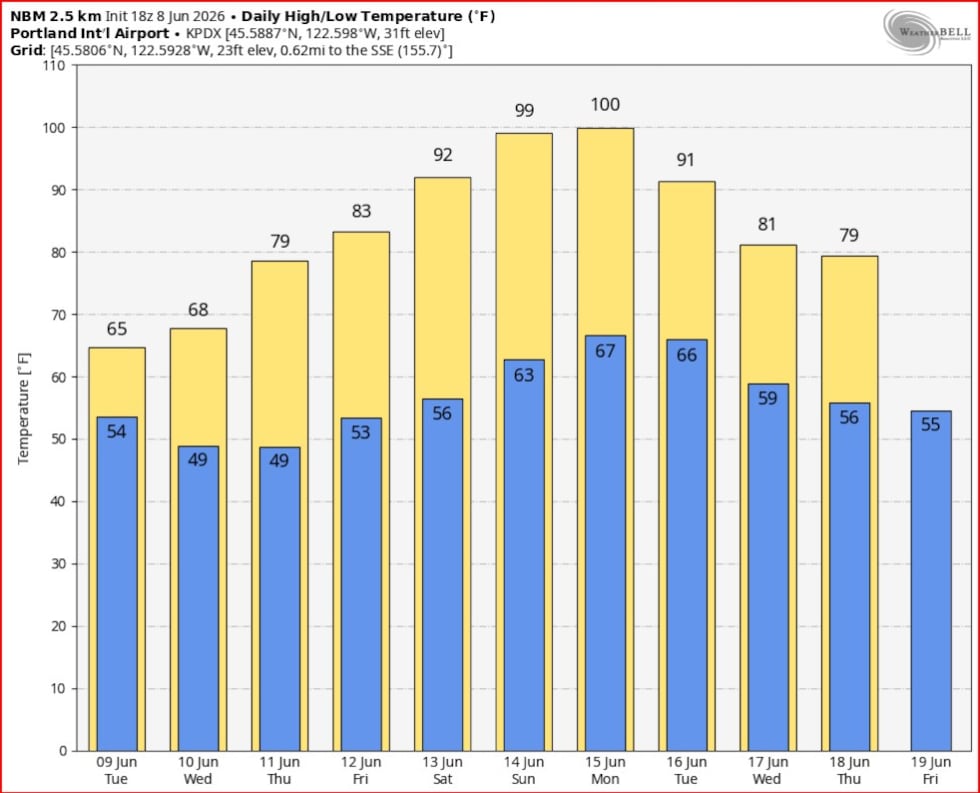
One other tool we use is the NBM (National Blend of Models), and the NWS relies heavily on that. But we’ve noticed it’s been running a bit too warm in previous warm spells this season. We will see how it does this time around, will we really hit 100 at PDX? Possibly, but we aren’t going quite that high.
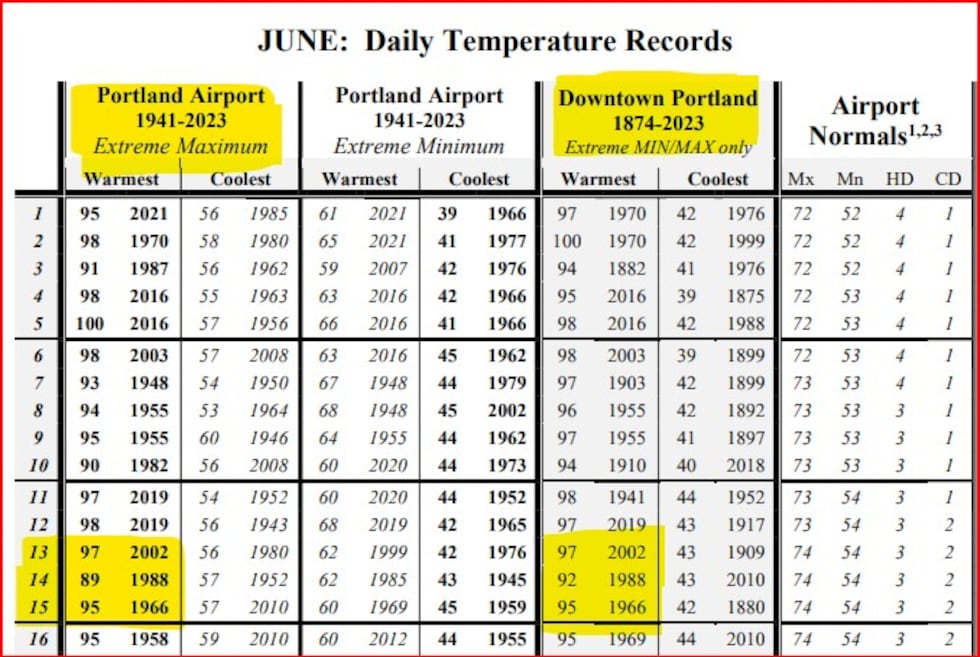
Heatwaves are one of the easiest weather events to predict in this area. It’s (usually) just sunny and the forecast temperatures are much higher than normal. We don’t have to worry about damaging wind, ice/snow, heavy rain, etc… All models are in good agreement on this event, it’s just a matter of whether we peak at 96° or possibly make it all the way to 100°. It sure is interesting that Sunday we’ll blow through the last remaining sub-90° June daily temperature record. There’s no other June day that has such a low record high temperature. Notice there are records for both PDX airport and Downtown Portland. I’ve highlighted Saturday through Monday at both locations.
That’s it for this soggy Monday afternoon, make sure you have a plan to stay cool later this weekend and early next week!
We’re pushing more into the digital world at KPTV, producing far more content than in the past. That means nowadays I’m generally publishing written blog posts like this only for severe/stormy/snowy/icy weather events. OR, if it’s really boring and the last post was a month ago.
If you are reading this, you likely have a strong interest in weather. Let me introduce two additional ways to get detailed weather information. Not A.I. slop and not automated, we spend a lot of time on these and enjoy producing them. Check them out!
FIRST ALERT WEATHER EXTRA SHOW (FAWX)
Did you know we are producing a DAILY (most weekdays) weather show at KPTV? I’m not aware of any other station in our area doing this. It’s typically 12-30 minutes of detailed weather information from our meteorologists. We take a deep dive into explainers and data that we don’t have time for on regular broadcast TV. Basically we have all the time in the world to talk about weather! Find old episodes here on our web page:
www.kptv.com/video-gallery/weather/first-alert-weather-extras/
These are LIVE at 7 p.m. on our FOX 12 OREGON streaming app. You add that on your Roku, Amazon Fire, or SmartTV. I know, seems complicated, but it’s just another little app right beside your Netflix, Amazon, HBO, etc… apps. That’s how mine is set up at home. These are on the web page typically by 8 p.m. or so if you can’t watch live.
FIRST ALERT WEATHER PODCAST
It’s still going strong! We record an episode most Wednesdays or Thursdays at 7 p.m., full of detailed weather information and a few laughs. We typically stream it live at the same time on our FOX 12 WEATHER Facebook page so that you can ask questions too. Within about 1.5 hours it’s on our web page (and app) here:
www.kptv.com/podcasts/weather/
We also play the podcast on our FAWX show too.
Copyright 2025 KPTV-KPDX. All rights reserved.
See More: https://www.ubirataonline.com.br