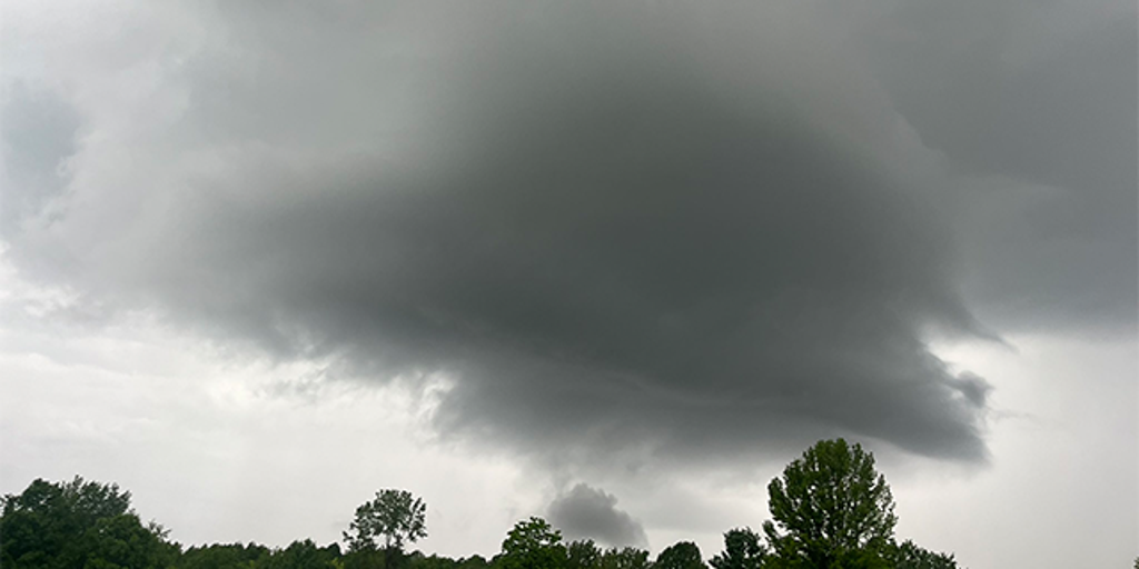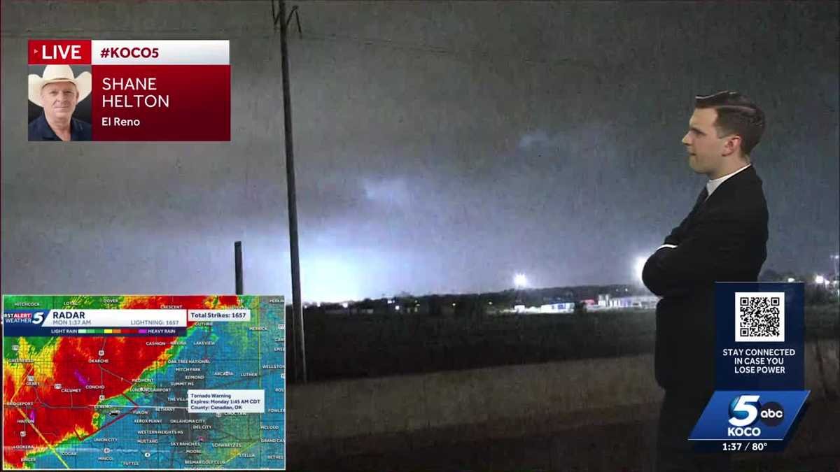

Oklahoma is seeing severe thunderstorms and a tornado risk Sunday night into Monday morning. >> Go to the KOCO weather page | Get KOCO on the Go | Subscribe to KOCO 5’s YouTube channel | Sign up for KOCO 5’s Morning Newsletter Below are updates from the severe weather threat. 1:35 a.m. Monday UpdateA tornado warning remains in effect until 1:45 a.m. for a storm located near El Reno, moving southeast at 35 mph. At least 8,201 electrical customers are without power in Oklahoma. 1:32 a.m. Monday UpdateRoad closures have already been reported during the severe storms. The eastbound lanes of Interstate 40 were blocked at mile marker 93 in Caddo County. In Washita County, the inside westbound lane of I-40 was blocked at mile marker 45.5. 1:27 a.m. Monday UpdateA tornado warning has been issued for Noble, Logan and Payne counties until 2 a.m. for a storm located near Orlando, moving east at 20 mph. This includes I-35 between mile markers 169 and 180. 1:25 a.m. Monday UpdateA 102-mph wind gust was reported near Hinton, outside of the tornado-warned area. Even those not in the tornado warning should be prepared for dangerous, life-threatening storms. 1:15 a.m. Monday UpdateA new tornado warning was issued for Canadian County for a storm located 5 miles north of Calumet, moving southeast at 30 mph. The warning lasts at 1:45 a.m.This includes Interstate 40 between mile markers 113 and 131. Take cover now. A tornado warning remains in effect for Kingfisher, Blaine and Canadian counties for a storm located 10 miles west of Okarche, moving southeast at 30 mph. Take cover now. The warning lasts until 1:30 a.m. 1:13 a.m. Monday UpdateThose living in the OKC metro have likely had their phones alert them of a destructive thunderstorm that could bring 80-mph wind gusts. Residents in the metro should take shelter away from windows. 1:02 a.m. Monday UpdateA tornado warning has been issued for Kingfisher, Blaine and Canadian counties until 1:30 a.m. The storm was located 6 miles east of Watonga, moving southeast at 25 mph. Those in the area should take shelter now. 12:55 a.m. Monday UpdateA line of severe storms warned for 80 mph wind gusts could hit the Oklahoma City metro by about 1:30 a.m., hitting OKC by 2 a.m. A severe thunderstorm warning was issued for Washita, Caddo, Roer Mills, Custer, Blaine and Beckham counties until 1:30 a.m. for a line of storms located 9 miles southeast of Cheyenne to 4 miles southeast of the Foss Reservoir to the Custer City area. The storms are moving southeast at 35 mph. The storms could bring 70 mph winds and quarter-sized hail. A severe thunderstorm warning was issued for Kay, Noble, Grant, Major and Garfield counties until 2 a.m. The line of storms was located 4 miles southwest of Chilocco to near Ponca City to near Douglas, moving southeast at 35 mph.12:46 a.m. Monday UpdateA severe thunderstorm warning was issued for Kingfisher, Caddo, Custer, Blaine, Dewey, Major, Garfield and Canadian counties until 1:30 a.m. This was tagged as a destructive storm that could bring 80 mph wind gusts and quarter-sized hail. The line of storms could move into the OKC metro by about 1:30. The storm was located along a line extending from 3 miles south of Lahoma to 3 miles south of Okeene to near Fay. It was moving east at 45 mph. 12:36 a.m. Monday UpdateAn 86-mph wind gust has been reported in the town of Putnam. At least 6,410 electric customers are without power in northwestern Oklahoma. 12:30 a.m. Monday UpdateA tornado warning has been issued for northwestern Kay County for a storm located near Braman. The storm is moving at 25 mph to the east. The warning lasts until 1 a.m. This warning includes Interstate 35 between mile markers 229 and 236. 12:20 a.m. Monday UpdateA tornado warning has been issued for Kay and Grant counties until 12:45 a.m. for a severe thunderstorm located 5 miles east of Caldwell, moving southeast at 15 mph. A severe thunderstorm warning was issued for Kingfisher, Ellis, Woods, Roger Mills, Alfalfa, Custer, Blaine, Grant, Dewey, Major and Garfield counties until 1:15 a.m. The storms could bring 70 mph winds and quarter-sized hail. The storms were located along a line extending from near Helena to 7 miles south of Orion to 7 miles southwest of Angora, moving east at 40 mph.12:15 a.m. Monday UpdateA severe thunderstorm warning was issued for Kay, Noble, Grant and Garfield counties until 1 a.m. The storm could bring 60 mph winds.The storm was located along a line extending 4 miles southwest of South Haven to 4 miles north of Kremlin, moving east at 30 mph.12:10 a.m. Monday UpdateSevere thunderstorms were located along a line extending from near Avard to 8 miles west of Dacoma to 5 miles east of Waynoka, moving east at 30 mph. The storms could bring 90 mph wind gusts and quarter-sized hail. An 89-mph wind gust was reported in the storm system. The National Weather Service said this is an extremely dangerous situation with tornado-like speeds. Midnight UpdateA tornado warning has been issued for Woods and Major counties until 12:30 a.m. for a storm located 11 miles southeast of Waynoka. The storm is moving southeast at 25 mph. Those in the area should take cover now. 11:55 p.m. Sunday UpdateThe tornado warning issued for the area of Freedom has been dropped, but the tornado warning near Waynoka remains. KOCO 5 Field Meteorologist Michael Armstrong says even those not in the tornado-warned areas could still see winds over 80 mph overnight, which could feel like an EF-0 tornado. 11:45 p.m. Sunday UpdateA tornado warning has been issued for southeastern Woods County for a storm located near Waynoka, moving east at 20 mph. Those in the area should take shelter immediately. The warning was issued until 12:15 a.m. 11:43 p.m. Sunday UpdateA wing gust over 70 mph was reported in Freedom, in the area of a tornado warning. The warning remains until midnight. 11:27 p.m. Sunday UpdateA tornado warning has been issued for Woods County for a storm located 11 miles northwest of Freedom, moving southeast at 15 mph. The warning was issued until midnight. 11:20 p.m. Sunday UpdateA severe thunderstorm warning was issued for Ellis, Woods, Harper, Major and Woodward counties until 12:15 a.m. The storms were located along a line extending from 13 miles south of Buttermilk to 11 miles north of Woodward to 12 miles southwest of May, moving southeast at 30 mph.The storms could bring 70 mph winds and quarter-sized hail. 10:55 p.m. Sunday UpdateA severe thunderstorm warning was issued for Ellis, Woods, Harper and Woodward counties until midnight. The storms could bring 70 mph winds and quarter-sized hail. The storms are located along a line extending from 11 miles north of Selman to 7 miles south of Buffalo to 4 miles south of Laverne, moving southeast at 30 mph.10:30 p.m. Sunday UpdateThe National Weather Service issued a severe thunderstorm warning for a destructive storm near Buffalo. The severe thunderstorm warning as issued for Harper County until 11:15 p.m., and the storms could bring 80 mph winds and ping-pong-ball-sized hail. 10:10 p.m. Sunday UpdateA severe thunderstorm warning was issued for Woods and Harper counties until 11 p.m. for a storm located along a line extending from 3 miles southeast of Clark State Lake to 6 miles north of Acres to 9 miles west of Englewood. The storms were moving southeast at 45 mph. They could bring 70 mph winds and ping-pong-ball-sized hail. 10 p.m. Sunday UpdateA severe thunderstorm warning was issued for Beaver County in the Oklahoma Panhandle until 11 p.m. The storm could bring 70 mph wind gusts and ping pong ball-sized hail. Half-dollar-sized hail was reported by KOCO 5 First Alert Storm Chaser Shane Helton near the town of Fargo in northwest Oklahoma. 9:40 p.m. Sunday Update severe thunderstorm warning was issued for Woodward County until 10:15 p.m. for a storm located 5 miles west of Sharon, moving southeast at 5 mph. The storms could bring 60 mph winds and quarter-sized hail. 8:30 p.m. Sunday UpdateA severe thunderstorm warning was issued for Woodward County until 9:45 p.m. The storm was located 7 miles west of Sharon, moving southeast at 5 mph. The storm could bring 60 mph winds and quarter-sized hail. A lightning strike south of Fargo sparked a fire as a severe storm moved through the area, producing hail and rotation.The Fargo Fire Department responded to the blaze, which began when lightning struck the ground, setting grass on fire. The fire spread to areas where trees had been cleared and piled up, igniting large piles of wood. 8:20 p.m. Sunday UpdateA severe thunderstorm warning was issued for Ellis and Woodward counties until 9 p.m. The storm was located near Fargo, moving south at 5 mph. The storm could bring golf-ball-sized and 60 mph wind gusts. 9 p.m. Sunday UpdateA severe thunderstorm warning was issued for Woodward County until 9:45 p.m. for a storm located 6 miles southeast of Fargo. The storm was nearly stationary. It could bring ping pong-ball-sized hail and 60 mph wind gusts. 7:45 p.m. Sunday UpdateA severe thunderstorm warning was issued for Ellis and Woodward counties until 8:30 p.m. The storm could bring 60 mph winds and half-dollar-sized hail. The storm was located 5 miles northeast of Fargo, and it was moving southeast at 5 mph. 7:25 p.m. Sunday UpdateA severe thunderstorm warning was issued for Ellis and Woodward counties until 8 p.m. The storm, which was located 6 miles south of Fort Supply, could bring golf-ball-sized hail and 60 mph wind gusts. The storm is moving east at 10 mph. 7:15 p.m. Sunday UpdateA severe thunderstorm warning was issued for a storm near Fort Supply, including parts of Woodward, Ellis, and Harper counties until 7:30 p.m. Quarter-sized hail and 60 mph wind gusts are possible. Another storm is also maturing south of Waynoka. It is moving east at 10 mph. A severe thunderstorm watch is in effect for Alfalfa, Dewey, Ellis, Garfield, Grant, Harper, Kay, Major, Noble, Woods and Woodward counties until 2 a.m. Monday. 6 p.m. Sunday UpdateKOCO 5 Meteorologist Joseph Neubauer says the first watch of the evening will likely be issued in northern Oklahoma. The watch will likely be for a severe thunderstorm that could bring damaging wind gusts and large hail. There is also a low tornado risk during the evening in northern Oklahoma. KOCO 5 Meteorologist Mikayla Smith shows what you can expect from the threat.Sunday Storm Risk The level 2 slight risk has been issued for the majority of Oklahoma down to areas near Lawton, Ada, and McAlester. Southern Oklahoma and the western half of the Panhandle have a level 1 marginal risk. The heat and breezy conditions provide the fuel for storms to develop. Oklahoma has a low tornado risk, and storms could produce hail. Oklahoma Tornado Risk The tornado risk is for the northern half of the state in the level 2 slight risk zone. The tornado index sits at 2 out of 10 for areas north of the OKC metro and Seminole and includes Woodward, Stillwater, Enid, Tulsa, Alva, Bartlesville, and Ponca City. The OKC metro has a tornado index of 1 out of 10. Oklahoma Hail Risk Hail is going to be the primary threat with these storms on Sunday. Northern Oklahoma near Woodward, Alva, and Ponca City could get golf ball-sized hail, and surrounding areas to Clinton, Enid, Stillwater, Tulsa, Bartlesville, and north of OKC may get ping pong ball-sized hail. Severe Storm Timeline Rain is pushing out of eastern Oklahoma Sunday morning, and the radar predictor is quiet throughout the afternoon. Storms, however, will pop back up around 6-8 p.m. in northern Oklahoma near Cherokee and Ponca City. Those showers and storms will continue south and toward the OKC metro during the overnight hours. Storms will continue through Monday morning, bringing rainfall to the OKC metro by 6 a.m. KOCO 5 First Alert Weather Team, led by Chief Meteorologist Damon Lane, has been certified by WeatheRate as providing the Most Accurate Forecast in Oklahoma City for 14 consecutive years. This outstanding achievement underscores KOCO 5’s unwavering dedication to delivering reliable weather forecasts to viewers.
Oklahoma is seeing severe thunderstorms and a tornado risk Sunday night into Monday morning.
>> Go to the KOCO weather page | Get KOCO on the Go | Subscribe to KOCO 5’s YouTube channel | Sign up for KOCO 5’s Morning Newsletter
Below are updates from the severe weather threat.
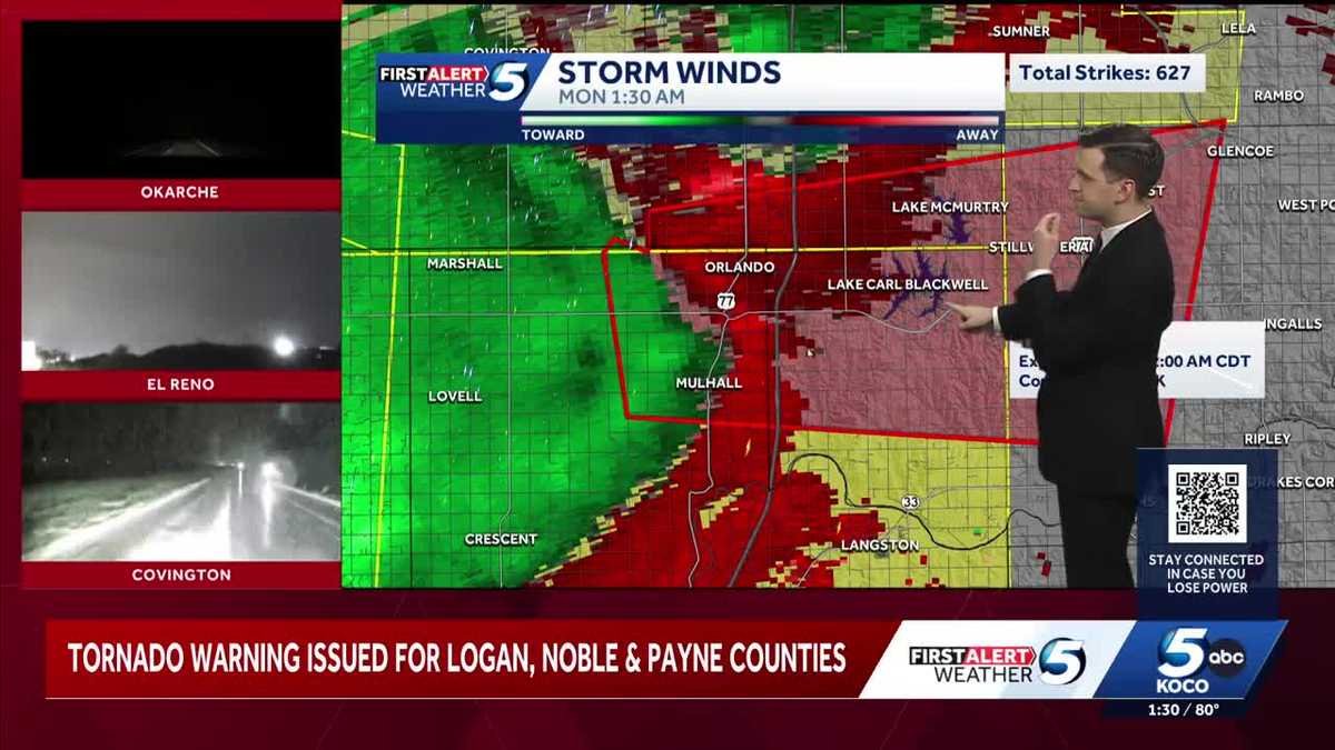
1:27 a.m. Monday Update
A tornado warning has been issued for Noble, Logan and Payne counties until 2 a.m. for a storm located near Orlando, moving east at 20 mph.
This includes I-35 between mile markers 169 and 180.
1:25 a.m. Monday Update
A 102-mph wind gust was reported near Hinton, outside of the tornado-warned area. Even those not in the tornado warning should be prepared for dangerous, life-threatening storms.
1:15 a.m. Monday Update
A new tornado warning was issued for Canadian County for a storm located 5 miles north of Calumet, moving southeast at 30 mph. The warning lasts at 1:45 a.m.
This includes Interstate 40 between mile markers 113 and 131. Take cover now.
A tornado warning remains in effect for Kingfisher, Blaine and Canadian counties for a storm located 10 miles west of Okarche, moving southeast at 30 mph. Take cover now.
The warning lasts until 1:30 a.m.
1:13 a.m. Monday Update
Those living in the OKC metro have likely had their phones alert them of a destructive thunderstorm that could bring 80-mph wind gusts. Residents in the metro should take shelter away from windows.
1:02 a.m. Monday Update
A tornado warning has been issued for Kingfisher, Blaine and Canadian counties until 1:30 a.m.
The storm was located 6 miles east of Watonga, moving southeast at 25 mph.
Those in the area should take shelter now.
12:55 a.m. Monday Update
A line of severe storms warned for 80 mph wind gusts could hit the Oklahoma City metro by about 1:30 a.m., hitting OKC by 2 a.m.
A severe thunderstorm warning was issued for Washita, Caddo, Roer Mills, Custer, Blaine and Beckham counties until 1:30 a.m. for a line of storms located 9 miles southeast of Cheyenne to 4 miles southeast of the Foss Reservoir to the Custer City area.
The storms are moving southeast at 35 mph.
The storms could bring 70 mph winds and quarter-sized hail.
A severe thunderstorm warning was issued for Kay, Noble, Grant, Major and Garfield counties until 2 a.m. The line of storms was located 4 miles southwest of Chilocco to near Ponca City to near Douglas, moving southeast at 35 mph.
12:46 a.m. Monday Update
A severe thunderstorm warning was issued for Kingfisher, Caddo, Custer, Blaine, Dewey, Major, Garfield and Canadian counties until 1:30 a.m.
This was tagged as a destructive storm that could bring 80 mph wind gusts and quarter-sized hail. The line of storms could move into the OKC metro by about 1:30.
The storm was located along a line extending from 3 miles south of Lahoma to 3 miles south of Okeene to near Fay. It was moving east at 45 mph.
12:36 a.m. Monday Update
An 86-mph wind gust has been reported in the town of Putnam.
At least 6,410 electric customers are without power in northwestern Oklahoma.
12:30 a.m. Monday Update
A tornado warning has been issued for northwestern Kay County for a storm located near Braman. The storm is moving at 25 mph to the east.
The warning lasts until 1 a.m.
This warning includes Interstate 35 between mile markers 229 and 236.
12:20 a.m. Monday Update
A tornado warning has been issued for Kay and Grant counties until 12:45 a.m. for a severe thunderstorm located 5 miles east of Caldwell, moving southeast at 15 mph.
A severe thunderstorm warning was issued for Kingfisher, Ellis, Woods, Roger Mills, Alfalfa, Custer, Blaine, Grant, Dewey, Major and Garfield counties until 1:15 a.m.
The storms could bring 70 mph winds and quarter-sized hail.
The storms were located along a line extending from near Helena to 7 miles south of Orion to 7 miles southwest of Angora, moving east at 40 mph.
12:15 a.m. Monday Update
A severe thunderstorm warning was issued for Kay, Noble, Grant and Garfield counties until 1 a.m. The storm could bring 60 mph winds.
The storm was located along a line extending 4 miles southwest of South Haven to 4 miles north of Kremlin, moving east at 30 mph.
12:10 a.m. Monday Update
Severe thunderstorms were located along a line extending from near Avard to 8 miles west of Dacoma to 5 miles east of Waynoka, moving east at 30 mph. The storms could bring 90 mph wind gusts and quarter-sized hail.
An 89-mph wind gust was reported in the storm system.
The National Weather Service said this is an extremely dangerous situation with tornado-like speeds.
Midnight Update
A tornado warning has been issued for Woods and Major counties until 12:30 a.m. for a storm located 11 miles southeast of Waynoka. The storm is moving southeast at 25 mph.
Those in the area should take cover now.
11:55 p.m. Sunday Update
The tornado warning issued for the area of Freedom has been dropped, but the tornado warning near Waynoka remains.
KOCO 5 Field Meteorologist Michael Armstrong says even those not in the tornado-warned areas could still see winds over 80 mph overnight, which could feel like an EF-0 tornado.
11:45 p.m. Sunday Update
A tornado warning has been issued for southeastern Woods County for a storm located near Waynoka, moving east at 20 mph.
Those in the area should take shelter immediately. The warning was issued until 12:15 a.m.
11:43 p.m. Sunday Update
A wing gust over 70 mph was reported in Freedom, in the area of a tornado warning. The warning remains until midnight.
11:27 p.m. Sunday Update
A tornado warning has been issued for Woods County for a storm located 11 miles northwest of Freedom, moving southeast at 15 mph. The warning was issued until midnight.
11:20 p.m. Sunday Update
A severe thunderstorm warning was issued for Ellis, Woods, Harper, Major and Woodward counties until 12:15 a.m.
The storms were located along a line extending from 13 miles south of Buttermilk to 11 miles north of Woodward to 12 miles southwest of May, moving southeast at 30 mph.
The storms could bring 70 mph winds and quarter-sized hail.
10:55 p.m. Sunday Update
A severe thunderstorm warning was issued for Ellis, Woods, Harper and Woodward counties until midnight. The storms could bring 70 mph winds and quarter-sized hail.
The storms are located along a line extending from 11 miles north of Selman to 7 miles south of Buffalo to 4 miles south of Laverne, moving southeast at 30 mph.
10:30 p.m. Sunday Update
The National Weather Service issued a severe thunderstorm warning for a destructive storm near Buffalo. The severe thunderstorm warning as issued for Harper County until 11:15 p.m., and the storms could bring 80 mph winds and ping-pong-ball-sized hail.
10:10 p.m. Sunday Update
A severe thunderstorm warning was issued for Woods and Harper counties until 11 p.m. for a storm located along a line extending from 3 miles southeast of Clark State Lake to 6 miles north of Acres to 9 miles west of Englewood.
The storms were moving southeast at 45 mph. They could bring 70 mph winds and ping-pong-ball-sized hail.
10 p.m. Sunday Update
A severe thunderstorm warning was issued for Beaver County in the Oklahoma Panhandle until 11 p.m. The storm could bring 70 mph wind gusts and ping pong ball-sized hail.
Half-dollar-sized hail was reported by KOCO 5 First Alert Storm Chaser Shane Helton near the town of Fargo in northwest Oklahoma.
9:40 p.m. Sunday Update
severe thunderstorm warning was issued for Woodward County until 10:15 p.m. for a storm located 5 miles west of Sharon, moving southeast at 5 mph.
The storms could bring 60 mph winds and quarter-sized hail.
8:30 p.m. Sunday Update
A severe thunderstorm warning was issued for Woodward County until 9:45 p.m. The storm was located 7 miles west of Sharon, moving southeast at 5 mph.
The storm could bring 60 mph winds and quarter-sized hail.
A lightning strike south of Fargo sparked a fire as a severe storm moved through the area, producing hail and rotation.
The Fargo Fire Department responded to the blaze, which began when lightning struck the ground, setting grass on fire. The fire spread to areas where trees had been cleared and piled up, igniting large piles of wood.
8:20 p.m. Sunday Update
A severe thunderstorm warning was issued for Ellis and Woodward counties until 9 p.m. The storm was located near Fargo, moving south at 5 mph.
The storm could bring golf-ball-sized and 60 mph wind gusts.
9 p.m. Sunday Update
A severe thunderstorm warning was issued for Woodward County until 9:45 p.m. for a storm located 6 miles southeast of Fargo. The storm was nearly stationary.
It could bring ping pong-ball-sized hail and 60 mph wind gusts.
7:45 p.m. Sunday Update
A severe thunderstorm warning was issued for Ellis and Woodward counties until 8:30 p.m. The storm could bring 60 mph winds and half-dollar-sized hail.
The storm was located 5 miles northeast of Fargo, and it was moving southeast at 5 mph.
7:25 p.m. Sunday Update
A severe thunderstorm warning was issued for Ellis and Woodward counties until 8 p.m. The storm, which was located 6 miles south of Fort Supply, could bring golf-ball-sized hail and 60 mph wind gusts.
The storm is moving east at 10 mph.
7:15 p.m. Sunday Update
A severe thunderstorm warning was issued for a storm near Fort Supply, including parts of Woodward, Ellis, and Harper counties until 7:30 p.m. Quarter-sized hail and 60 mph wind gusts are possible.
Another storm is also maturing south of Waynoka. It is moving east at 10 mph.
A severe thunderstorm watch is in effect for Alfalfa, Dewey, Ellis, Garfield, Grant, Harper, Kay, Major, Noble, Woods and Woodward counties until 2 a.m. Monday.
6 p.m. Sunday Update
KOCO 5 Meteorologist Joseph Neubauer says the first watch of the evening will likely be issued in northern Oklahoma. The watch will likely be for a severe thunderstorm that could bring damaging wind gusts and large hail.
There is also a low tornado risk during the evening in northern Oklahoma.
KOCO 5 Meteorologist Mikayla Smith shows what you can expect from the threat.
Sunday Storm Risk
The level 2 slight risk has been issued for the majority of Oklahoma down to areas near Lawton, Ada, and McAlester. Southern Oklahoma and the western half of the Panhandle have a level 1 marginal risk.
The heat and breezy conditions provide the fuel for storms to develop. Oklahoma has a low tornado risk, and storms could produce hail.
Oklahoma Tornado Risk
The tornado risk is for the northern half of the state in the level 2 slight risk zone. The tornado index sits at 2 out of 10 for areas north of the OKC metro and Seminole and includes Woodward, Stillwater, Enid, Tulsa, Alva, Bartlesville, and Ponca City.
The OKC metro has a tornado index of 1 out of 10.
Oklahoma Hail Risk
Hail is going to be the primary threat with these storms on Sunday.
Northern Oklahoma near Woodward, Alva, and Ponca City could get golf ball-sized hail, and surrounding areas to Clinton, Enid, Stillwater, Tulsa, Bartlesville, and north of OKC may get ping pong ball-sized hail.
Severe Storm Timeline
Rain is pushing out of eastern Oklahoma Sunday morning, and the radar predictor is quiet throughout the afternoon. Storms, however, will pop back up around 6-8 p.m. in northern Oklahoma near Cherokee and Ponca City.
Those showers and storms will continue south and toward the OKC metro during the overnight hours.
Storms will continue through Monday morning, bringing rainfall to the OKC metro by 6 a.m.
KOCO 5 First Alert Weather Team, led by Chief Meteorologist Damon Lane, has been certified by WeatheRate as providing the Most Accurate Forecast in Oklahoma City for 14 consecutive years. This outstanding achievement underscores KOCO 5’s unwavering dedication to delivering reliable weather forecasts to viewers.
See More: https://www.ubirataonline.com.br