

SHORT TERM FORECAST
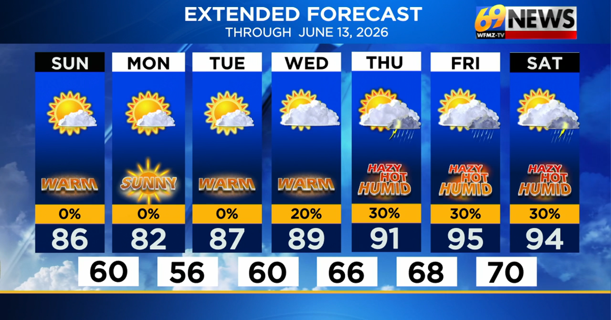
SUNDAY: Mostly sunny and pleasant. High: 84
SUNDAY NIGHT: Mainly clear and comfortably cool. Low: 58
MONDAY: Comfortable with abundant sunshine. High: 82, Low: 56
FORECAST SUMMARY
After a stormy and hot Saturday, we’ll close out the weekend on a pleasant and more comfortable note. Afternoon highs today will mainly be in the mid-80s amid lower humidity levels and mostly sunny skies. Monday will also be a fantastic day with high temperatures in the lower 80s under sunny skies and low humidity. This reprieve does not last long however, as temperatures quickly warm up back into the upper-80s and lower 90s for the middle of the week, and up into the mid- 90s and possibly upper 90s to close the week. Dew points will also be climbing well into the 60s and 70s by the latter part of next week, meaning it will certainly feel hot and sticky and like we are well into summer. A few showers and thunderstorms may also return with that heat and humidity late in the week, but this activity will likely be very hit-or-miss meaning it will be tough to get any solid relief with our drought situation.
DETAILED FORECAST
SUNDAY
In the wake of Saturday evening’s cold front, we’ll see drier and more pleasant air settle in to round out the weekend. For Sunday, we likely start off muggy with some patchy fog first thing in the morning. Look for mostly sunny skies to unfold however as the day progresses, and more importantly, dew points will drop into the comfortable 50s by the afternoon as a northwest wind blows either side of 10mph. There is the slightest of chances of a brief sprinkle, mainly in New Jersey, but most if not all should stay dry. High temperatures will still be warm in the mid 80s, but with the drop in dew points, it will feel pleasant to be out and about.
EARLY WEEK
High pressure will influence our weather pattern as the new week begins, so we should see a fair amount of sunshine. High temperatures should be in the lower 80s Monday and then jump to the upper 80s Tuesday, and near 90 Wednesday. So, while the heat starts to crank up, the humidity will stay on the comfortable side. There may be a disturbance that tries to develop and bring a passing shower or two late Wednesday but as of now it’ll be limited on who will see anything.
LATE WEEK
Temperatures continue to heat up toward the end of the week as highs climb to the low to mid 90s Thursday and possibly mid to upper 90s Friday. And for both days we also expect a mix of sun and clouds with higher dew points and humidity values. With some humid air in place, a shower or t-shower could bubble up, but if anything develops, it looks to be more isolated. Nighttime lows will turn milder too, mainly in the lower 70s.
TRACK THE WEATHER:
LINKS: HOUR BY HOUR | RADAR | TRAFFIC
See More: https://www.ubirataonline.com.br